GPS comparison tests
Naar navigatie springen
Naar zoeken springen
For introduction see also GPS
Here are screenshots made on 29 Sep 2024 during a walk in the park, with in one hand an iPhone 14 (with dual band gps) en in the other iPhone 12 (without dual band).
For test purposes the OpenBomenKaart application uses diagnostic tweaks, see screenshots
The exact path I walked is shown in magenta. I traced this in Google Maps with this tool keene.edu/campus/maps/tool/. I consider this the reference track. Note that Google Maps and OSM sometimes don't line up exactly, e.g. for paths in the park.
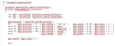
Every second GPS coordinates are read, complemented by a number for 'accuracy'. I translate the latter in a figure ranging from 1-5 ('zwak'-'spot on'). See code example below.
